-40%
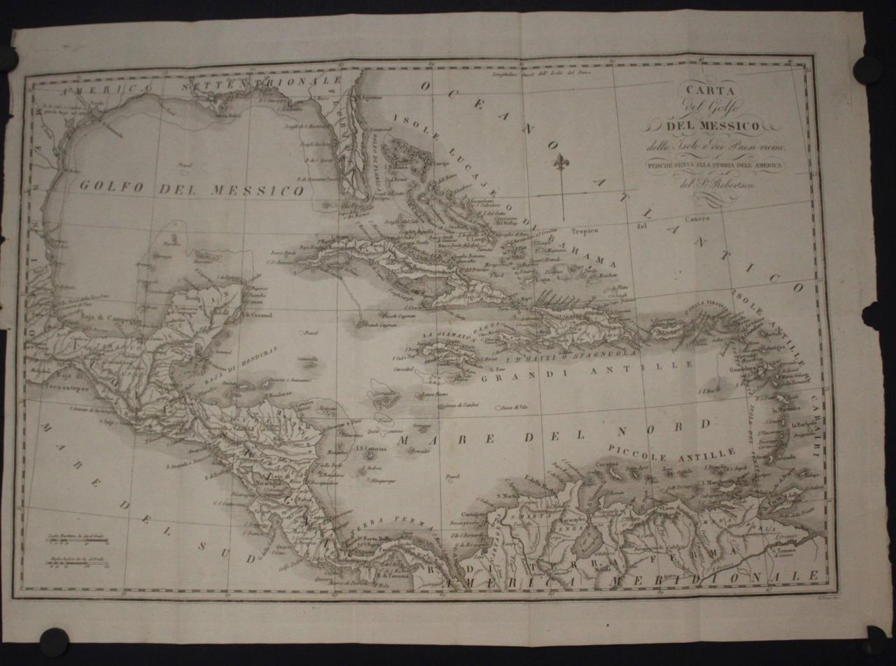
WEST INDIES CARIBBEAN FLORIDA MEXICO CENTRAL AMERICA 1824 ROBERTSON ANTIQUE MAP
$ 14.02
- Description
- Size Guide
Description
WEST INDIES CARIBBEAN FLORIDA MEXICO CENTRAL AMERICA 1824 ROBERTSON ANTIQUE MAPWEST INDIES CARIBBEAN FLORIDA MEXICO CENTRAL AMERICA 1824 ROBERTSON ANTIQUE MAP
Description
Carta del Golfo del Messico, dell'Isole e Paesi adiacenti. Perchè serva alla Storia d'America del Sr. Robertson
.
Description:
Striking and highly detailed fine unusual Italian Edition by Giuseppe Pezze of the William Robertson's copper engraved map of the Gulf of Mexico & Caribbean. Covers eastern Mexico, Florida & part of south-eastern United States, Central America and northern coast of South America. Notes cities, rivers, lakes, reliefs and islands.
Date:
1824
( undated )
Dimension:
Paper size approx.:
cm 49,9 x 35,6
Condition:
Very strong and dark impression on good paper. Map uncolored. Wide top and lower margins. Good right lateral margin, with minor loosing at the central side. Short left lateral margin, partially missing at the lower side. Small foxing.
Plate folded. Conditions are as you can see in the images
.
Writer:
William Robertson FRSE FSA Scot (19 September 1721 – 11 June 1793) was a Scottish historian, minister in the Church of Scotland, and Principal of the University of Edinburgh. "The thirty years during which [he] presided over the University perhaps represent the highest point in its history." He made significant contributions to the writing of Scottish history and the history of Spain and Spanish America. He was Chaplain of Stirling Castle and one of the King's Chaplains in Scotland.
All of the maps we sell are ORIGINALS. We guarantee all of our maps to be authentic. We do our best to describe the condition of our maps as accurately as possible. Due to the age and type of paper, some imperfections are to be expected. Please examine the images provided carefully, and if you have any questions please ask and we will be happy to help.
A Certification of Authenticity ( COA ) can be issued on request
I will send you all your item by Registered and Insured Airmal or by TNT/DHL with covering Insurance
If you buy more than one item you have to pay just one only shipping cost
Any map purchased from us may be returend for any reason for a full refund.
Shipping: Customs may be charged on international shipments. All customs charges are the responsiblity of the buyer and are not included in the selling price.
About:
Old Times
Rare Antiquarian Books & Maps Sellers
Our Firm was founded in 1983 and we are specialized on antiquarian works on paper concerning Antique Rare Maps, Atlases and Travel Books of all the World.
Our Firm adheres to the Codes of Ethics outlined by the Italian Antiquarian Booksellers Association ( ALAI ) and International League of Antiquarian Booksellers ( ILAB ).
All items sold by OLD TIMES are genuine and a Certificate of Authenticity (COA) will be happily supplied on request.
Many Thanks
Cesare Giannelli
OLD TIMES
RARE ANTIQUARIAN BOOKS & MAPS SELLERS
Via Cortonese, 70
06124 - Perugia
Italy
Phone/Fax: 0039 - 075 - 505 20 18
http://www.oldtimesrarebooks.com
View My Feedback
View My Other Items For Sale
View My About Me page
Visit My eBay Store
Add me to your Favorite Sellers
Click images to enlarge
Images sell!
Get Supersized Images & Free Image Hosting
Create your brand with Auctiva's
Customizable Templates.
Attention Sellers - Get Templates
Image Hosting, Scheduling at Auctiva.com.
Track Page Views With
Auctiva's Counter
